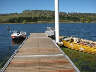
Have a look at the three photos above and tell me where they were taken! Down on the coast? On one of Australia's major inland waterways?
Actually, they were taken at the Costa del Armidale at a height of about 1182m (roughly 3850ft) and precisely 30.17.03 South and 151.44.10 East. Find it on Google Earth.
We're now firmly into Autumn according to the schedule of seasons, but the first of April dawned brilliantly clear and heralded a warm day. Indeed today's forecast maximum temperature was an amazing 23C, especially given our altitude and time of year, so we decided to head for the Costa del Armidale. This is where local residents go sailing, canoeing, swimming (if you're brave) and fishing.
The water body in question is Lake Malpas, which is impounded by a dam of the same name. This lake supplies Armidale with its water, and it is so large that it could keep supplying water for about 5 years even if there were to be no rain. In practice, it has never failed, for Malpas is on the Guyra plateau whose rainfall is both high and reliable. The following pictures show the surrounding hilly terrain, the dam, and the little Gara river which flows from beneath the dam wall. Nice scenery! And gorgeous location. The only problem is the chilly temperatures in Winter, which officially starts on 1 June and lasts for 3 months. However, Lake Malpas is about the same latitude as Cairo (a little over 30 N or S in both cases), so Winter temperatures hardly equate to the Cairngorms! One of the main peaks there, Beinn a' Bhùird, tops out at 1196m. The little of Guyra is itself higher than Ben Nevis, the highest spot in the UK.
AS


1 comment:
Wow. What a readership. And I thought I was one of just a few reading your blog. Had a great trip yesterday to RAF Brize Norton where I toured a C17 heavy lift cargo plane, had lunch in the officer's mess, watched the new "Voyager" transport aircraft taxi close by and take off etc. A brilliant day out. Richard.
Post a Comment