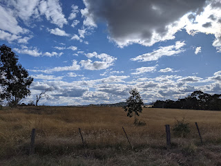
At loss to use up my day effectively, I decided to take a drive around our district. As always, I tried to take an unusual route. And today I decided to drive up Rockvale Road north-east of Armidale. Rather than travel its full length, I decided to try the Herbert Park Road instead and, around 10 kmm north of our town, I did a left turn. I drove a further 40 km north towards Guyra on a sunny and warm Winter afternoon.
I was entranced by the whole picturesque route travelling about a third of the way on a sealed road before doing much of the rest on a good quality dirt road. Close to Armidale the route took me past many small hobby farms, but further out the farms became large and the homesteads were widely scattered. In fact, much of the countryside looked empty! Over something like 40 km I never saw another car! I was all alone. So I stopped the car from time to time and tothe last ook a heap of lovely pictures like those shown here. Just have look at the lovely countryside! The first ones were taken at 1000 m above sea level and the last ones were about 1300 m - much higher on the New England Tablelands. Even at that altitude, the temperature recorded by may car was still close to 15 C - even in mid-winter.
As you can see, there's a lot of wide pasture-land, mostly brown in colour except for the occasional green paddocks where irrigation water is available and / or the pastures are top-dressed with nutrients.
A good quality dirt road!
One of the most evident characteristics of the pastures was the absence of livestock - sheep and cattle.
There great vistas. Looking south I could make out high country peaks some 60 km away.
The route had several river crossings in valleys like these below. One, the Gara Fiver, flows down to the spectacular waterfall I reported on earlier this. year.
The cone shown in the distance below is likely to be the core of an extinct volcano - much of the Tablelands area is covered in igneous rocks with thin top-soil that makes grain farming unlikely - but leads to widespread pasture.
Well, I did see occasional livestock later on in my trip. This field contained, unusually, both cattle and sheep.
At last, the dirt road became sealed - good quality work!
AS


