Thursday 30 December 2021

Second Falls in Two Days

Just one day after visiting Wollomombi falls we drove out to the gorge(ous) country to see yet another famous waterfall - Dangar's Falls, which also plunges steeply into a deep and rather inaccessible valley. However, there is a long path whose return journey will take some 4-5 hours that manages to reach the bottom - and both I and Rebecca have done that trip.

Here are several views of Dangar's Falls taken from a viewing platform from the south side after quite a long walk. Again, the geology of the gorge region looks igneous rather than sedimentary. The third and fourth images here show a little of the deep and twisting gorge downstream.

The left image below focuses upsteam from the falls and shows the rapids accompany the rapidly descending river. The right image shows the river a little further up racing zig-zag towards the falls.


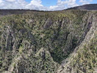
I like the images below because they show the wider and wild landscape of the national park.


And here's a picture of the falls taken from the north side - partially hidden from view


This next image was taken from a viewing platform just at the top of the falls and show the water plunging down.


And, finally, here's a lovely image of the falls from a greater distance on the north side.


Nice views, eh?

AS


Wollomombi Walk

This Christmas holiday we had a great time hosting our daughter Rebecca, her son Max - now 17 years old - and her partner Rob. On the 28th December, Bec cand Rob accommpanied me to the wonderful Wollomombi Falls in the world heritage listed Oxley Wild Rivers National Park. We chose there because of the lovely walking trails, the great scenery, and the massive amount of water flowing down the Wollomombi river as the result of recent heavy rains. We were not disappointed with what we saw - and nor were the many visitors to the national park whom we met en route.

Let's have a look at some of the images we witnessed. On the left below is the new viewing platform and as you'll see from the angle taken the Woolomombi falls is on the left side of the platform while the less intense Chandler Falls are on the right. On the right we can see the large valume of water in the creek and its high vertical drop.


The next views were taken downstream from the Wollomombi falls and show the deep and twisting gorge through which the water flows. The rocky sides to the wall shown on the left image seem to be igneous. There appears to be no walkable track along the gorge floor. On the right, you can see the kinds of terrain through which the water flows downstream - often heavily forested and also rocky.


Here I am admiring the scenery and all rugged up because of the occasional showers on a windy summer's day when the temperature failed to rise beyong about 16 C.


Here are some more views of the gorgeous terrain (please excuse the pun) and a close-up image of the falls' vertical drop. However, hidden from view, the water is tumbling down a long slope and the two components taken together make Wollomobi one of the highest in Australia.

This next picture shows the Wollomombi and Chandler Falls alongside each other from a lookout some distance away.


Obviously, it's a great location and one I cherish greatly. 

AS


Monday 20 December 2021

December Garden 2021

After all the rain we've had recently, out garden is blooming - heaps of lovely flowers and shrubs. I took some pictures this morning and show them below. By the way, Dot does much more in keeping the garden looking nice. I do mow the lawns occasionally and trim their edges! Enjoy or criticise as you wish!


Please forgive me for not knowing the names of most of these plants / shrubs ... that's more Dot's domain. Feel free to guess what they are and email their names! This is blog post 1254. I wonder when I'll reach 2022? Surely not next year!

AS


Sunday 5 December 2021

Dangar's Falls Torrent

After what is now c. 170 mm of rain over the last 20 days I decided today to take a trip to Dangar's falls to witness what I presumed would be a fantastic display of falling water. I wasn't wrong. The pictures shown here were breathtaking. They include not just the massive drop but also the rapid stream-flow leading to the top of the main falls. Although there were quite a few cars parked nearby, while taking pictures of the views taken here I saw no-one. I presume quite a few people were taking the longer trails around the falls.


AS

Friday 3 December 2021

Yet another flood!

 In the last two weeks or so, Armidale has according to our rain-gauge received >150 mm  of rain (c. 6 inches for those in the UK and USA). So we've had our maybe the 5th flood event of 2021. Put another way, if my family in the south of the UK received that kind of rainfall across an entire year they'd be drowning in about 156 inches of rain. We've had major flood events all over eastern Australia, with many towns and villages awash in water, and major highways cut. There's no way we could drive to Canberra via the inland right now, yet about two years ago we were in a terrible drought.

What caused the change? Well the answer lies in two partially connected events. Currents in the Indian ocean have delivered very warm water to the NW of our continent, creating moist air that heads right in our direction through favourable wind patterns. Secondly, Australia's east coast is influenced by a periodic El Nina event that draws warm water from the west coast of South America in our direction. This also contributes high moisture air. Putting the two events together we've heaps of rain, although Armidale has been at the bottom end of rainfall totals because we're in a kind of rain shadow. For many parts of inland NSW the November rainfall totals were the highest in 100 years!!

Wanting some pictures? We here are three of Wednesday's flood event ... the highest I think of 2021. Out for my morning walk I came across these views ... and by the way I was not the only one taking pictures at around 7 am! Faulkner Street - our main avenue into the town centre was about 0.7 m under water a blocked to all traffic. However, I crossed over the flood via the pedestrian bridge on the left.


And here I am on the bridge looking east on the first and weston the second. Dumaresq Creek is usually about 2 m wide, but far more on this occasion. And you can see from the ripples how fast the water was running.


AS

Saturday 27 November 2021

So

 Most Saturday mornings I go for a walk with my colleague, Alun, near Tilbuster Creek just north of Armidale. It takes us through beautiful but rather empty countryside far from traffic and other people. We almost decided not to go today because of heavy rain over the week and fear that the grass and gravel paths we take might be waterlogged. 

Well, we decided to take a gamble, so we met up at 7 am at the end of Blue Wren road and headed off on foot. It didn't take long for our fears to be confirmed. Here's Alun wondering how to cross a creek-bed that's normally dry ... we didn't even try!


And, as we expected, the main river, Tilbuster Creek was running high as these pictures show. The paths alongside varied from soggy to fairly dry, so we made fair progress albeit in very wet shoes and socks.


And here am I in my hippy gear admiring the scenery. By the way, it wasn't cold at 7.30 am. The minimum temperatures overnight just recently have reached as much as 19 C (66 F) because of cloud-cover. As you can see from this picture, the sky was a dull grey. Although we experienced no rain, ti started to pour as I drove home. We were lucky that we weren't just as soggy as our footware!
 

The entire journey lasted 90 minutes, but the countryside was empty apart from plenty of birds of various species. We met no fellow walkers, encountered no cattle - although we had to dodge a lot of pooh, and saw no kangaroos - although they're normally plentiful. Let me know if you'd like to join us on our next weekly trip!

AS

Monday 22 November 2021

Memories of Spring

 Armidale usually has a vibrant musical calendar with many orchestral concerts during the course of a year. However, COVID-19 has severely restricted the number of concerts. So it was relief that our NSW government has recently removed lock-down provisions and opening up people gathering to listen to our great local orchestra. Even so, members of the audience had to demonstrate double vaccination to get in and then wear a face-mask.

Yesterday's concert was extraordinarily beautiful in terms of works performed and quality of playing. We started with a lovely rendition of Mozart's Die Entfuhring aus dem Serail (K484, 1782). Next came 4 concertos by Antonio Vivaldi written in 1720, each portraying serially Spring, Summer, Autumn and Winter. Each involves a solo violinist and the two young performers - Emily Thompson and Eliza Scott - were brilliant in their roles. The audience gave the whole orchestra and the soloists tumultuous applause after that performance, which - in my view, mirrored professional orchestras in our major cities.

After a short intermission, we reconvened for a great performance of Aaron Copland's Appalachian Spring. I adore this beautiful work, partly because I've explored much of the USA's Appalachian range and partly because it was composed in the same year as I and Dot were born ... 1945.

I was able to take a few pictures of the event  ... and even a few videos. However, I've tried uploading a few of the latter, but cannot get them to work. Maybe they'll work for you!


AS

Yet another flood

Armidale has just received nearly 75 mm (c. 3 inches) of rain in the last 3 days. That's amazing given that Australia is a relatively dry continent. Now the inland rivers making up the Murray-Darling system are in full flood. Likewise, the eastern flowing streams like Dumaresq Creek, which traverses Armidale, are also  in flood. I took an early morning walk in the rain today - armed with a large umbrella - to have a look at the creek, fully expecting it to be in flood. I was not mistaken - it's the largest of the 4 flood events we have experienced this year. This is what I saw:


The picture above shows a considerable volume of water flowing rapidly across Faulkner Street. Vehicles were prevented from trying to negotiate a route across the river.


Note how green the grass is after all the rain have in recent months! The last of the three pictures shows a large family of ducks having fun on the rapidly flowing water.

AS


Monday 8 November 2021

Roaming New England

 I love exploring our region and, in the last couple of days, had some great experiences. I was out for a walk on Saturday when I came across a group of kangaroos. If you count them you'll see 5 on the other side of the fence, but there were several more in the background. This was privately owned hobby-farmed land, but I suspect the owners were delighted with their intruders!


Then yesterday Dot and I went to explore some parts of our region where we'd never been before. For those who know our region or would like to look it up on Google maps, we drove northeast up Rockvale road for maybe 20 km through lovely hilly countryside which was a lovely shade of green after lots of rain. Then we turned off on to Chandler Road which, to our surprise, was sealed despite being very narrow and only served a few very large-scale local livestock farms. Basically, we travelled eastwards for about another 15+ km through increasingly lovely, but almost empty, countryside. We admired the lovely views shown here - all taken from a single spot. In essence they look north-east, east, and south east. And in the distance lies the mountain range which is the highest point in Australia between the Snowy Mountains to the south and north Queensland just south of Cairns - a distance of 3,000 km apart! Point Lookout - the highest point - is 1564 m, or 5131 feet.


The immediate area in these photos is some of Australia's best grazing country. The rainfall tends to be high and reliable and many of the properties are huge - some around 10,000 hectares  (24,700 acres).

Shortly after taking these images we turned right on to Thorpleigh Road which ran through more grazing land for another c. 15 km. Again, we past through no settlements and only a few grazing properties. The quality of this road was rather lower than Chandler Road, with much of it unsealed gravel, but again the landscapes were lovely. Eventually we joined the lovely Waterfall Way which links Armidale to the coast. The junction was about half-way between Wollomombi to the east and Hillgrove to the west.

I'm glad we took this drive yesterday in quite good weather. Today our region is experiencing torrential rain. Since rain started Sunday evening we have received c. 51 mm of rain (about 2 inches). To the west of us, Gunnedah received almost 100 mm (c. 4 inches) in one day ... and Australia is supposed to be the driest continent! I'd like to ask my UK readers how many times a year do they get 1 inch of rain in a day.

AS