Wednesday 30 May 2018

And Now for Something Bizarre

As we travelled from Cradle Mountain, where we'd stayed just one night, towards Coles Bay on the other - eastern - side of Tasmania which is a good entry point to the Freycinet Peninsula National Park, we briefly visited a remarkable location. We went to the Promised Land. More than that, we stopped in the village of Lower Crackpot! Both officially exist and Lower Crackpot even has its own postcode. Their total population is also amazing ... just 44 people!  Why on earth stop there? By the way, just down the road is another strange place called 'Nowhere Else'.

Well, the village is home to one Tasmania's leading tourist attractions called Tazmazia. And the owners have constructed a mass of different mazes for all age groups from small children through adults and the chief maze is modelled the UK's Hampton Court Maze. Alongside the mazes there is a model village for kids to roam around and that village has, amazingly, a diplomatic quarter populated with 'toy' embassies from many countries on earth.

Let's have a look. The first two pictures prove I'm not inventing this place!


And here, quite obviously we have some mazes.


They were festooned with such advice as these notice-boards:


The village had a correction centre for children and this picture show a determined Max escaping from his incarceration. The other kid was less lucky


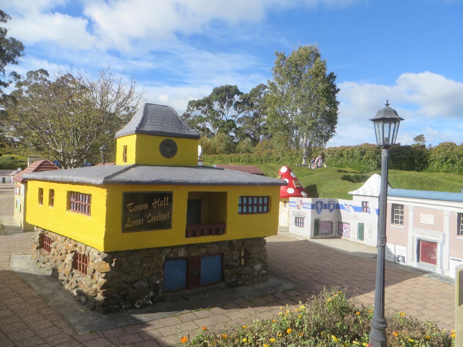
The toy village had some lovely imaginative buildings and great surrounding scenery.


And just have a look at the diplomatic quarter. You don't have to be a genius to diagnose which countries are represented in these three structures


You've got it! We've got India, the United States and, of course, that historically ensnared country, Great Britain!


AS


And so to Cradle Mountain

This mind-blowingly scenic trip was about to crank up a notch when we departed Strahan for Cradle Mountain, one of the most renowned destinations in Australia. The journey took us via Zeehan to the Murchison Highway and on to Rosebery before turning right and travelling eastwards toward our accommodation at the Cradle Mountain Lodge. Nice though it was, I have no pictures of where we stayed. Perhaps that's because (a) it was getting dark by the time we arrived and (b) I departed early the following morning to take Bec for her hugely anticipated hike up Cradle Mountain. Alas for her, the mountain was shrouded in mist and she took a much shorter walk around the mountain's base. While that occurred, I drove the long way back to the Lodge, had breakfast, packed up our gear and headed to the beautiful Dove Lake ... some of my readers might be pleasantly surprised to find a famous lake named after them.

Anyway, our journey to  Cradle Mountain, which started almost immediately after disembarking from our harbour cruise, took us through miles of mountain scenery and more thick rain-forest vegetation.


And early next morning Bec and I arrived at Dove Lake to find Cradle Mountain enveloped in thick misty cloud - not exactly enticing to mountain climbers.


Later on, the rest of us arrived on the shores of Dove Lake to see a National Parks truck attempting to go for a swim. At this point we met Bec returning from her early morning walk and she and Max headed off to the eastern side of the lake to do a spot of rock-hopping,something that Max loves to do.


I liked this sign which heralds the start of the overland track to Lake St Clair noted in an earlier post. I can't imagine what Wombat Poo looks like!


And this is the rock that Max and Bec climbed. I think the dude on the far right may be Max.


Meanwhile we walked past the boat-shed where the truck had vanished (under water?) and left a boat.

And we explored a few paths in the shadow of Cradle Mountain, which was still enshrouded in mist before meeting up with Bec and Max who were still intact. we drove back to the park's visitor centre parallel to Dove River shown here and we went for another short walk to see a pretty waterfall.


The track there and back went along a boardwalk through boggy and mossy terrain.


 While we mostly encountered great weather during our Tasmanian visit, it was a shame that this day was dull and damp.


Just before driving to our next surprising destination, we visited a sanctuary for two iconic local animal species: the Tasmanian Devil and Spotted Quolls. The former are somewhat endangered and the latter are the second largest of the world's surviving carnivorous marsupials.

The Devils are cute little things and the Quolls are not far behind.


AS

Scimming the Waters

After our lovely steam train ride we embarked on another pleasant journey, this time a voyage in a modern catamaran across the relatively smooth waters of Macquarie Harbour. I might add that, once again, Bec selected that up-market accommodation for our trip which included meals and drinks and the more panoramic views on the top floor. The vessel in front of us here is a similar model.

And here on the right is Strahan's pleasant shoreline.


Macquarie harbour is a huge expanse of sheltered water nearly 35 km (22 miles) long and up to 10 km (6.2 miles) wide.


The captain is seated here at his controls, heading out towards the open sea of the southern ocean.


Interesting light play on the inner harbour, while below we're heading to the estuary.


Here we're heading back into Macquarie Harbour with the open ocean behind us. Luckily, the often hugely stormy waters of the 'roaring forties' were flaccid during our trip. Here's the eastern shoreline.


The right hand picture was interesting for Dot and me since we own the farm in the middle of the water! I'm not joking. You're looking a salmon farm owned by Tassal (Tasmanian Salmon) in which our self managed superannuation fund (SMSF) is invested.


Another interesting cloud-scape.

Here we are approaching the mouth of the Gordon River amidst lovely forested mountains, eagerly anticipated by some of the passengers standing on the catamaran's bow.


Just sit back and enjoy the scenery as the river narrows upstream and the banks steepen.


Eventually the craft berthed and we alighted for a rain-forest walk - with Bec and Dot leading the way.


As with many of the rain-forests we visited in Tasmania, there were many fallen trees decaying on the ground, but home to fungi, mosses and saplings.

On the return journey to Strahan we stopped off at Sarah Island. This was one of the worst of all penal settlements in Tasmania, with extremely harsh conditions that led to many escape attempts, some of which ended in cannibalism! It only lasted 11 years from 1822 to 1833 before abandonment. Now there are just a few pieces of wreckage left to explore.

Like other penal settlements, Sarah Island has a beautiful perspective, as this view suggests. Here's Dot waiting to explore the island.


However harsh the island's human life, these pictures also have a kind of beauty about them, as does the final picture across Macquarie Harbour


Do you know what? This last picture reminds me of Britain's Inner Hebrides, which I've explored many times. And that leads to another interesting thought. This expanse of water is named Macquarie Harbour after Governor Lachlan Macquarie, one of the early and perhaps most important colonial governors. Now, Macquarie was born in a now ruined crofting village on the Isle of Ulva just off the coast of the larger Island of Mull in Scotland's Inner Hebrides. I've visited this birthplace where the Australian government has erected a memorial to that event. This picture is awfully reminiscent of Hebridean vistas. And, by the way, Lachlan is buried in a family mausoleum in central Mull, which I've also visited.

What a memorable trip.

AS