Sunday, 28 March 2021

Dangar's Falls in flood

 I took a trip out to our gorge country today to see how all our recent rain has affected the river system and our gorgeous waterfalls. In particular, I headed to Dangar's Falls, which tumble vertically into a deep gorge and I was stunned by what I saw.

Have a look at these pictures. Here's the fast flowing water taken from an iron bridge over the creek near the car park. The latter was jammed with cars as people had headed like me to the spectacular falls 


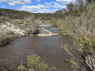
This is the stream running hard over the rocky landscape above the falls.


And here's a picture looking the rapid stream flow heading down to the top of the falls.


This shows the torrent of water heading over the top of the falls - about the most water I have ever seen. There's a little lake at the bottom, which is better shown in the following picture.


The river then rushes in zig-zag fashion through the bottom of the gorge.


I have a video of the falls and friends and families are welcome to request it separately.

AS

NERAM art display at Wyuna

 We might now be well into Autumn, but yesterday was a lovely day with the temperature still around 22 C (72 F). Dot and I had received an invitation to go to a rural property at Kelly's Plains organised by the New England Regional Art Museum (NERAM), which is one of regional Australia's best galleries - if not THE best. I gather that the display of paintings, sculptures and some plants was being used as a fund-raising venture by the gallery and there were certainly lots of people present at this open air event. The property, Wyuna, has several historic buildings and is also these days used for rearing horses and teaching them show-jumping. But it also has lovely and picturesque gardens in which the art-works were displayed.


I sat down for a mug of coffee and a slice of cake right next to the old cart shown above, and couldn't resist taking a photo of it. Nice refereshments were avaiable for those attending the event.

One of the local private schools -The New England Girls School (NEGS) displayed handiworks presumably made by their students


I thought I'd taken pictures of some of the paintings and sculptures on display, but looking at the rest of the pictures suggest I was overwhelmed by the attractiveness of the gardens instead. 


For example, the were many models of animals like sheep modelled from wire ... but I cannot see here any in my pictures despite intending to display them!


Oh well! These look like 3 metal stumps!


Here's the main homestead.

And a nice garden shair!

Oh Well! That's it.

AS

Saturday, 27 March 2021

Another Flood Event

 You may recall that I reported on Armidale's drenching rain at the end of February 2021 when we received something like 100 mm (4 inches) of rain over several days. Well, events have repeated at the end of March, which has been another dampish month. This time we received 80 mm of rain in just two days, this time in particularly heavy downpours. So we've had close to 400 mm of rain (or c. 10 inches) since the starrt of 2021, our best start to the year climatically for quite a while. As a result we've major flood events along Dumaresq Creek, which runs through town. In addition, our local dams are now full and we've come off wate-use restrictions.

The wonderful rain at the start of this week immediately generated the highest water levels in Armidale's creeklands that I've seen in years. And here are some images of the height and speed of water travelling through town. However, the first thing that caught my eye after getting out of my car to photograph events were these fungii growing around the base of a tree. Don't they look edible!


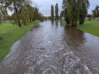
From this spot I case my eye over the raging water. Also notice how green our grass nowis as a result of extensive rain.


The following morning after the above 4 images were taken, I went on my usual morning walk and decided to revisit the creeklands to see how events were unfolding. Well, the water was higher and flowing faster. Here you can see the water rushing across one the N-S roads into town - the one we usually take. Not today, however!


This image looks westerly and upstreem from the elevated footpath across the creek, which was still quite usable.


Rotating 180 degrees to the left, this was the view downstream and you can see in the distance one of the few creek crossings now usable.


Now I am on the bridge just mentioned looking westward and you can see a hell of a lot of water. Fortunately Armidale is a hilly town, so no homes were flooded as far as I know. Helping to create this outcome is Armidale's land-use planning, which prevents home construction in floodable areas. As you can see from the picture below, the land to the right rises quite steeply away from the river bank.


I love such events as shown above, provided no-one is harmed and property is damaged.
AS