I had an interesting experience today when university staff were invited to the University's SMART farm on the edge of campus to watch a Queensland company demonstrate the use of drones in agriculture. Here's the paddock where the display was held and it contained just one sheep and a plot of grass where a particular species had been planted and I gathered that experiments were under way to see how this grass variety impacted on the animal's growth rate and wool production. Incidentally, this view was taken only about half a km from my office!
Anyway, the team members producing the display used their drones (plural) to map grass growth / supply in this and surrounding fields, and they claimed to be able to assess the volume of wool on sheep in such a paddock - and much other information potentially useful in farm management like the incidence of weeds, water supply and so on.
One of the drones was quite large and could be controlled over vast distances, with its range over 40 km (25 miles) from base. Here it is in the air above us:
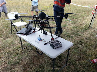
It actually had 8 motors to give it great manoeuvrability and precision location, and the motors / blades were clustered in four pairs as shown here:
You can just make out the four arms at the end of which is a pair of rotating blades. One can see via the lap-top the data being gathered and images of where the drone is located. The little dome on top hides a lot of electronics one wouldn't want to get wet and the 'vehicle' if that is what it is can be held relatively stable even in strong wind.
Max might like to see the control panel, which has some similarities with the drone he received for Christmas but has rather more gizmos / levers, as one would expect for a multi-thousand dollar model compared with Max's sub-100 AUD version.
And here's the second, smaller, drone being explained by one of the team.
Towards the end the team fielded many questions from the audience, ranging over licenses to fly these things, knowledge bases, controlling drones in areas frequented by civil aviation, legal responsibilities should things go wrong, uses of drones - for example locating lost bush-walkers, geological surveying, taking videos of prominent tourist spots, looking for illegal logging / clearing of bush-land and so on. It was an interesting experience for all these reasons.
AS


No comments:
Post a Comment