Burrewarra Point is located close to Tomakin and is the top pink bit on the larger scale middle map, whereas Broulee Island, the subject of the previous post, is the southern pink bit. Both locations are part of a much larger marine park.
Unlike the previous post, which circumnavigated around an island, the path at the Burrewarra headland snakes through attractive woodland across ridges and offers stupendous high-up views of sea, bays, beaches and islands. See if you agree with me!
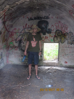
An old munitions block-house - stored military equipment in WWII. Now festooned with graffiti inside.
Part of our party of 9 - including me.
An early glimpse of the sea.
Lovely coastal scenery.
Woodland pathways, with some easily climbable trees, as Ella and Flynn demonstrated rapidly. They might be very young but they're great at exploring such opportunities, first Ella and then Flynn once his sister has show the path to happiness.
The headland is festooned with Banksias, which grow these large flowers / seed pods.
Eventually catching up with each other. As you'd imagine correctly three different generations don't walk at the same pace. And capacities vary even within one generation! I'm used to speed-walking despite my 70+ years, which was useful as I could 'run' ahead of the group to take these photos.
These coastal views, mainly east and south impressed me.
And an amazed Bec heads out on a dangerous limb!
Ella re-living her exploits up the tree!
I have one further observation. The Burrewarra headland us home to rather strange 'lighthouse' and I'm sure I took some photos of it. However, they're untraceable, so go to the following web-site to see what I'm talking about: https://en.wikipedia.org/wiki/Burrewarra_Point_Light . One can't go up the structure and it's not particularly beautiful, but it has an interesting history.
I've copied a photo of the structure from the wikipedia entry:

AS


No comments:
Post a Comment