Monday, 16 November 2020

A Walk on the Walls of China

On the last full exploring western NSW, we left Pooncarie and headed to Mungo National Park. On our way there we saw at the roadside a remarkable display of trash probably discarded by a local farm property. I've not anything like it before. Let's have a look:


This sign at the side of the road caught our eyes and it accurately describes the display. Whenever bras boots and pianos are discarded they are displayed artistically at the kerbside! 


Here, for example, is a tree smothered in discarded foot-ware.


The pianos were a bit hard to miss! Have you ever seen two pink-coloured pianos setting at the road-side?

And the bras decorate this tree nicely.

So when you want toss things out in future you might consider, say, nailing your underwear to a tree on your property or displaying a discarded shirt on something that looks like a scarecrow. I guess, however, that the region's hot dry weather might prevent used clothing from wasting away.

A little further on we came to a sign introducing us to the National Park. You've probably never heard of it, but it is world famous because it was here that archaeologists discovered the remains of Mungo man whose skeleton was dated back some 42,000 years. At his death he was probably aged about 50 and 1.7 m tall, perhaps a little lower than the average today.


After another quick tour of the visitor's centre, we joined a group of people booked on a tour of the park.

After the visitor's centre, we all saw the interior of a wool shed created in the 19th century by a local farm. It was here that sheep would be shorn of their wool annually. It would then be transported on a barge down the Darling River towards local and overseas markets


Our party took a bus out across Lake Mungo, which had little if any water. We headed to the walls of China whose name was given by Chinese migrants to the area. Shown her in the distance, it is an accumulation of wind-blown sand, which over the centuries, has steadily moved eastwards - a process going on today. Going east, it has been blown up a ridge some 40 + km in length. It's a long wall, but nowhere the length of the Chinese version!

Getting closer, we can the whitish sand rising in front of us. People wishing to visit and climb the wall have to be in a tour party. People can drive their cars to a fence and loom the sand, but tours parties are under supervision of a guide who can prevent damage to the site. 

Here we are slowly walking  towards the ridge.

I think that's Dot at the back. Notice that the sand in front is white, while beyond that the sand turns darker.
Here we are now on the darker bit and, as you can see, the surface is becoming rockier.

However, there is a slight amount of vegetation also.

On the way up I noticed what looks like a skeleton in a rock face ...but not Mungo man. Maybe it's a relative of the crocodile! 


Now we're getting into really rocky terrain as this and the following picture show

Again, there's a minimal vegetation including small trees and shrubs.


Now our party has reached the top of the 'wall' and looks out westwards across the lake bad which is green from all the small shrubs that cover it.

As you can see from the two picture below, the sand and rock can create some impressive ladnscapes.


After returning to the bus, we were driven back to the Lake Mungo lodge where we met up with and hand fed some voracious Emus like the one's shown here. They seem to like visitors, which is unsurprising since they got a good feed. After going back to the visitor information centre, we returned to Rebecca's car and drove off for a long circular tour behind the wall - i.e. to the east of it.


Travelling southwards down the western side of the wall, the countryside was again sandy with sparse vegetation.


The sand became hillier as we skirted the southern edge of the 'wall'


And, as we crossed to the eastern side we were met by another dead flat plain. At least it was a lovely green colour with all the brasses and shrubs adorning it.

We even found something called a "lake" containing a small amount of water

The figure you see is Rebecca.

I also liked the wispy cloud-scape that you can see. 


Travelling northwards we slowly encroached back on to the sand.

This would have been maybe 30 km north of where we rounded the southern end of the 'wall'.

As we rounded the top end of the wall, we saw a path leading to the top of the dune and both Rebecca and I decided to join various parties of people heading to the top.


Here I am resting on a sign advertising the supposed 'lake' as we headed back to the tourist centre.

All up it was a lovely journey. We then headed down a long dirt road to Balranald just north of the Victorian border.

We stayed the night this pretty little town and, in the morning went down to another of the great river systems making up the Murray - Darling Basin.


This is the Murrumbidgie, which has its source not far from Canberra, which is about an 8 hour drive away.

Again, here's Rebecca admiring the scenery.

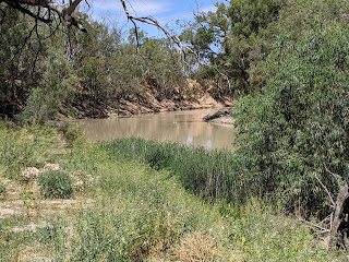
The rover itself was, like the Darling we saw earlier, flowing only very slowly and with what looked like a low water volume.


And here is the last photo posted on our roughly 10 day journey.


AS

Sunday, 15 November 2020

Towards Lake Mungo

At last the time has come to leave Broken Hill and spend a day travelling south to the tiny village of Pooncarie where we stayed the next night. Historically, this little village of maybe 50 people was a key port for barges navigating the Darling River, transporting mainly agricultural in the huge region, 500 km across from Wentworth to Wilcannia. Burke and Wills also camped there on their ill-fated transcontinental trek in 1860. By the way, the village gets in name from Pooncaira, an Aboriginal word meaning 'large sandhill' - for a good reason we discovered that evening and the following day. 

Let's first have a look at a remarkable landscape ... or should I say waterscape ... travelling southwards. We visited the Menindee Lakes area where a large number of extensive lakes is fed by the Darling river system. When river-flow is strong, as it has been in recent fairly wet months, the lakes fill with water, but in dry periods they shrink rapidly. We found ourselves lucky to see a lot of water! 


First, we saw a lovely green park alongside one of the lakes.

And here's another view of one of the lakes - a large body of water hosting numerous birds and presumably fish, though I didn't see any myself.

As you can see here, with much greater inflow the lake could extend further in area

Looking out over the lake, however, we can also see that quite a lot of trees dot the shallow water at the lake's edge.

Dot and Rebecca were so enthralled by the views that they spent some time, camera in had, taking pictures.

Look also at how placid the waters were - almost as flat as a tack.

I also liked the thin cloudscape.

After viewing some of the lakes, we walked back to the car to resume our trip south.


The trip south towards Pooncarie was a lonely one. Our vehicle saw no-one travelling in our direction and only maybe 2 or 3 going in the opposite direction. But the distance of 127 km (79 miles) was through largely empty countryside. When we arrived at our destination, we found a tiny community with just a few basic services like the local pub. However, the village did have one major attraction: the Darling River. And we soon headed down to have a look.

The Darling is part of Australia's largest river system - the Murray Darling Basin. Some of the rivers are also very long. For example, rivers feeding into the Darling system start just west of Armidale where I'm typing this blog. Armidale to Pooncarie by road is 1,125 km by road (or 700 miles. With all its bends, the river will be longer!
But even after heavy rains in part of the catchment, the river's water level and speed of flow were still quite low. Here's Rebecca admiring the peace and quiet of the scenery.

Following our glimpse of the river, we jumped in the car again and headed out for a quick survey of the next day's destination - Lake Mungo National Park. This will be one of the most glorious parts of the entire trip, as the next blog post will show.

Have a look at the picture on the left. What do you think you're looking at? It's something priceless. These are foot-prints of Aboriginal people in the sand - now preserved. How old are they? The answer is mind-blowing: 20,000 years - long before humans reached Britain.

Here's the tourist information centre, which we'll explore in the next post.
And here's the 'piece de resistance'.

We're looking eastwards across Lake Mungo, currently almost bone dry.

And can you see white hills in the distance? You're looking at the Walls of China!!!!! These are not the Great Walls of China, obviously. But the name was bestowed by a Chinese visitor in the 19th century who thought they looked similar.

These walls are the surrounding ecosystem are the main subject of the next post.

I hope these posts enthuse you as much as us. We were enthralled by this entire trip and recommend it enthusiastically.

AS


Thursday, 12 November 2020

Living Desert Park Sculptures

 This is my last post before moving on from the Broken Hill district and it concerns a wonderful collection of rock sculptures out in the semi-desert country surrounding that city. Again, it explains why the region is well worth a visit.

The collection is located in the 'Living Desert Park' which  is nestled amongst the Barrier Ranges and is located 12km from the city. It is a 2400ha reserve, which was established in 1992. Surprisingly, the sculptures were provided  by a large international range of peopleThrough park management, Broken Hill City Council protects native flora and fauna by better management for the sustainability of the local ecosystem, while providing a wonderful tourist attraction - the sculptures - that lures visitors out to the park..

On top of the park's highest hill, there are 12 sandstone sculptures, created in 1993 by a group of artists from all over the world. Collectively they marry art & nature. Let's have a look both these domains, starting with a view over the semi-desert landscape. It's wide-open and scarcely occupied countryside.

Then come the rock sculptures, each varied and interesting.


Recognise these two people, who are admiring the art-works? Bec and Dot.


That's just 6 of the 12 sculptures but I think you'll agree with me that they're interesting and well-done - with notes alongside explaining the works and their creators. So desert scenery can be visually great.

AS