At last the time has come to leave Broken Hill and spend a day travelling south to the tiny village of Pooncarie where we stayed the next night. Historically, this little village of maybe 50 people was a key port for barges navigating the Darling River, transporting mainly agricultural in the huge region, 500 km across from Wentworth to Wilcannia. Burke and Wills also camped there on their ill-fated transcontinental trek in 1860. By the way, the village gets in name from Pooncaira, an Aboriginal word meaning 'large sandhill' - for a good reason we discovered that evening and the following day.
Let's first have a look at a remarkable landscape ... or should I say waterscape ... travelling southwards. We visited the Menindee Lakes area where a large number of extensive lakes is fed by the Darling river system. When river-flow is strong, as it has been in recent fairly wet months, the lakes fill with water, but in dry periods they shrink rapidly. We found ourselves lucky to see a lot of water!
First, we saw a lovely green park alongside one of the lakes.
And here's another view of one of the lakes - a large body of water hosting numerous birds and presumably fish, though I didn't see any myself.
As you can see here, with much greater inflow the lake could extend further in area
Looking out over the lake, however, we can also see that quite a lot of trees dot the shallow water at the lake's edge.
Dot and Rebecca were so enthralled by the views that they spent some time, camera in had, taking pictures.
Look also at how placid the waters were - almost as flat as a tack.
I also liked the thin cloudscape.
After viewing some of the lakes, we walked back to the car to resume our trip south.
The trip south towards Pooncarie was a lonely one. Our vehicle saw no-one travelling in our direction and only maybe 2 or 3 going in the opposite direction. But the distance of 127 km (79 miles) was through largely empty countryside. When we arrived at our destination, we found a tiny community with just a few basic services like the local pub. However, the village did have one major attraction: the Darling River. And we soon headed down to have a look.

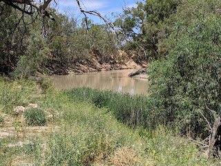
The Darling is part of Australia's largest river system - the Murray Darling Basin. Some of the rivers are also very long. For example, rivers feeding into the Darling system start just west of Armidale where I'm typing this blog. Armidale to Pooncarie by road is 1,125 km by road (or 700 miles. With all its bends, the river will be longer!
But even after heavy rains in part of the catchment, the river's water level and speed of flow were still quite low. Here's Rebecca admiring the peace and quiet of the scenery.
Following our glimpse of the river, we jumped in the car again and headed out for a quick survey of the next day's destination - Lake Mungo National Park. This will be one of the most glorious parts of the entire trip, as the next blog post will show.
Have a look at the picture on the left. What do you think you're looking at? It's something priceless. These are foot-prints of Aboriginal people in the sand - now preserved. How old are they? The answer is mind-blowing: 20,000 years - long before humans reached Britain.
Here's the tourist information centre, which we'll explore in the next post.
And here's the 'piece de resistance'.
We're looking eastwards across Lake Mungo, currently almost bone dry.
And can you see white hills in the distance? You're looking at the Walls of China!!!!! These are not the Great Walls of China, obviously. But the name was bestowed by a Chinese visitor in the 19th century who thought they looked similar.
These walls are the surrounding ecosystem are the main subject of the next post.
I hope these posts enthuse you as much as us. We were enthralled by this entire trip and recommend it enthusiastically.


No comments:
Post a Comment